Geographical location. On the huge isthmus between the Black and Caspian seas, from the Taman to the Absheron peninsula, there are the majestic mountains of the Greater Caucasus.
North Caucasus- This is the southernmost part of Russian territory. The border runs along the ridges of the Main, or Watershed, Caucasian Range Russian Federation with the countries of Transcaucasia.
The Caucasus is separated from the Russian Plain by the Kuma-Manych depression, on the site of which a sea strait existed in the Middle Quaternary.
The North Caucasus is an area located on the border of the temperate and subtropical zones.
The epithet “the best” is often applied to the nature of this territory. Latitudinal zonality is replaced here by vertical zonality. For a resident of the plains of the Caucasus Mountains - shining example"multi-storey™" of nature.
Remember where the southernmost point of Russia is located and what it is called.
Features of the nature of the North Caucasus. The Caucasus is a young mountain structure formed during the period of Alpine folding. The Caucasus includes: Ciscaucasia, Greater Caucasus and Transcaucasia. Only the Ciscaucasia and the northern slopes of the Greater Caucasus belong to Russia.

Rice. 92. Orographic scheme of the Caucasus
The Greater Caucasus is often presented as a single ridge. In fact, it is a system of mountain ranges. From the Black Sea coast to Mount Elbrus is the Western Caucasus, from Elbrus to Kazbek is the Central Caucasus, east of Kazbek to the Caspian Sea is the Eastern Caucasus. In the longitudinal direction, an axial zone is distinguished, occupied by the Vodorazdelny (Main) and Bokovy ridges.
The northern slopes of the Greater Caucasus form the Skalisty and Pastbishchny ridges. They have a cuesta structure - these are ridges in which one slope is gentle and the other is steep. The reason for the formation of a quest is the interlayering of layers composed of rocks of different hardness.
The chains of the Western Caucasus begin near the Taman Peninsula. At first, these are not even mountains, but hills with soft outlines. They increase when moving to the east. Mountains Fisht (2867 m) and Oshten (2808 m) - the highest parts of the Western Caucasus - are covered with snowfields and glaciers.
The highest and grandest part of the entire mountain system is the Central Caucasus. Here even the passes reach an altitude of 3000 m; only one pass - the Cross Pass on the Georgian Military Road - lies at an altitude of 2379 m.
The highest peaks in the Central Caucasus are the double-headed Elbrus, an extinct volcano, the highest peak in Russia (5642 m), and Kazbek (5033 m).
The eastern part of the Greater Caucasus is mainly the numerous ridges of mountainous Dagestan (translated as the Country of Mountains).

Rice. 93. Mount Elbrus
Various tectonic structures took part in the structure of the North Caucasus. In the south there are folded block mountains and foothills of the Greater Caucasus. It is part of the alpine geosynclinal zone.
Oscillations earth's crust were accompanied by bending of the earth's layers, their stretching, faults, and ruptures. Through the cracks that formed, magma poured out to the surface from great depths, which led to the formation of numerous ore deposits.
Uplifts in recent geological periods - Neogene and Quaternary - turned the Greater Caucasus into a high-mountainous country. The rise in the axial part of the Greater Caucasus was accompanied by an intense subsidence of the earth's layers along the edges of the emerging mountain range. This led to the formation of foothill troughs: in the west of the Indolo-Kuban and in the east of the Terek-Caspian.
The complex history of the geological development of the region is the reason for the richness of the subsoil of the Caucasus in various minerals. The main wealth of the Ciscaucasia is oil and gas deposits. In the central part of the Greater Caucasus, polymetallic ores, tungsten, copper, mercury, and molybdenum are mined.
In the mountains and foothills of the North Caucasus, many mineral springs were discovered, near which resorts were created that have long gained worldwide fame - Kislovodsk, Mineralnye Vody, Pyatigorsk, Essentuki, Zheleznovodsk, Matsesta. Sources vary in chemical composition, in temperature and are extremely useful.

Rice. 94. Geological structure North Caucasus
The geographical location of the North Caucasus in the south of the temperate zone determines its mild, warm climate, transitional from temperate to subtropical. The parallel of 45° N runs here. sh., that is, this territory is equidistant from both the equator and the pole. This situation determines the amount of solar heat received: in summer 17-18 kcal per square centimeter, which is 1.5 times more than the average European part of Russia receives. With the exception of the highlands, the climate in the North Caucasus is mild and warm; on the plains, the average July temperature everywhere exceeds 20°C, and summer lasts from 4.5 to 5.5 months. Average January temperatures range from -10 to +6°C, and winter lasts only two to three months. In the North Caucasus is the city of Sochi, which has the warmest winter in Russia with a January temperature of +6.1°C.
Using the map, determine whether in the foothills of the North Caucasus there are any obstacles to the path of arctic or tropical air masses. What atmospheric fronts pass near this area? Analyze on maps how precipitation is distributed in the North Caucasus, explain the reasons for this distribution.
The abundance of heat and light allows the vegetation of the North Caucasus to develop in the north of the region for seven months, in the Ciscaucasia - eight, and on the Black Sea coast, south of Gelendzhik - up to 11 months. This means that with the appropriate selection of crops, you can get two harvests a year.
The North Caucasus is distinguished by a very complex circulation of various air masses. Various air masses can penetrate this area.
The main source of moisture for the North Caucasus is the Atlantic Ocean. Therefore, the western regions of the North Caucasus are characterized by high rainfall. The annual precipitation in the foothill areas in the west is 380-520 mm, and in the east, in the Caspian region, it is 220-250 mm. Therefore, in the east of the region there are often droughts and hot winds. At the same time, they are often accompanied by dusty, or black, storms. Storms occur in the spring, when the upper layers of parched soil, still weakly held together by recently emerged plants, are blown away by strong winds. Dust rises in clouds into the air, obscuring the sky and the sun.
Measures to combat black storms include properly planned forest shelterbelts and advanced agricultural technology. However, until now, due to black storms, several tens of thousands of hectares have to be reseeded (re-seeded), from which the most fertile layer of soil is blown away during dust storms.
Highland climate very different from the plains and foothills. The first main difference is that much more precipitation falls in the mountains: at an altitude of 2000 m - 2500-2600 mm per year. This is due to the fact that mountains trap air masses and force them to rise. At the same time, the air cools and gives up its moisture.
The second difference in the climate of the highlands is the decrease in the duration of the warm season due to the decrease in air temperature with height. Already at an altitude of 2700 m on the northern slopes and at an altitude of 3800 m in the Central Caucasus there is a snow line, or the border of “eternal ice”. At altitudes above 4000 m, even in July, positive temperatures are very rare.
Remember how much the air temperature decreases when you rise for every 100 m. Calculate how much the air cools when you rise to a height of 4000 m, if its temperature at the surface of the earth is +20 ° C. What happens to the moisture in the air?
In the mountains of the Western Caucasus, due to the abundance of precipitation, a four to five meter layer of snow accumulates during the winter, and in the mountain valleys, where it is blown away by the wind, up to 10-12 m. The abundance of snow in winter leads to the formation of snow avalanches. Sometimes one awkward movement, even a sharp sound, is enough for a thousand-ton mass of snow to fly down a steep ledge, destroying everything in its path.
Explain why there are practically no avalanches in the mountains of the Eastern Caucasus.
Think about the differences that will be observed in the change in altitudinal zones on the western and eastern slopes.
The third difference in the high-mountain climate is its amazing diversity from place to place due to the height of the mountains, slope exposure, proximity or distance from the sea.
The fourth difference is the uniqueness of atmospheric circulation. Cooled air from the highlands rushes down through relatively narrow intermountain valleys. When descending for every 100 m, the air warms up by about 1°C. Descending from an altitude of 2500 m, it heats up by 25°C and becomes warm, even hot. This is how a local wind is formed - the foehn. Hairdryers are especially frequent in the spring, when the intensity of the general circulation of air masses sharply increases. Unlike a foehn, when masses of dense cold air invade, bora is formed (from the Greek boreas - north, north wind), a strong cold downward wind. Flowing through low ridges into an area with warmer rarefied air, it heats up relatively little and “falls” at a high speed along the leeward slope. Bora is observed mainly in winter, where the mountain range borders the sea or a large body of water. The Novorossiysk forest is widely known (Fig. 95). And yet, the leading factor in climate formation in the mountains, which greatly influences all other components of nature, is altitude, leading to vertical zonation of both climate and natural zones.

Rice. 95. Scheme of formation of the Novorossiysk forest
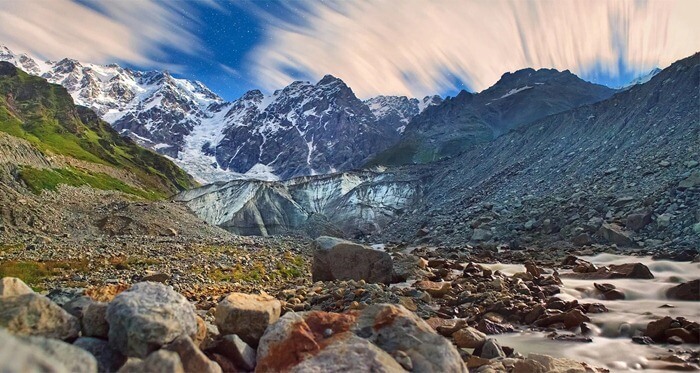
The rivers of the North Caucasus are numerous and, like the relief and climate, are clearly divided into lowland and mountainous. There are especially numerous turbulent mountain rivers, the main source of food for which is snow and glaciers during the melting period. The largest rivers are the Kuban and Terek with their numerous tributaries, as well as the Bolshoy Yegorlyk and Kalaus, which originate in the Stavropol Upland. In the lower reaches of the Kuban and Terek there are floodplains - vast wetlands covered with reeds and reeds.

Rice. 96. Altitudinal zone of the Greater Caucasus
The wealth of the Caucasus is its fertile soils. In the western part of Ciscaucasia, chernozems predominate, and in the eastern, drier part, chestnut soils predominate. The soils of the Black Sea coast are intensively used for gardens, berry fields, and vineyards. The world's northernmost tea plantations are located in the Sochi region.
In the Greater Caucasus Mountains, altitudinal zonation is clearly expressed. The lower zone is occupied by broad-leaved forests with a predominance of oak. Above are beech forests, which with height transform first into mixed and then into spruce-fir forests. The upper border of the forest is at an altitude of 2000-2200 m. Behind it, on mountain meadow soils, there are lush subalpine meadows with thickets of Caucasian rhododendron. They pass into short-grass alpine meadows, followed by the highest mountain belt of snowfields and glaciers.
Questions and tasks
- Using the example of the North Caucasus, show the impact geographical location territory on the features of its nature.
- Tell us about the formation of the modern relief of the Greater Caucasus.
- On contour map designate the main geographical objects of the region, mineral deposits.
- Describe the climate of the Greater Caucasus, explain how the climate of the foothills differs from the high-mountain regions.
The vast majority of the peaks included in the list of the highest mountains in Russia on the map belong to one mountain system - the Greater Caucasus. This huge mountain range is located between the Black and Caspian Seas. The southerners are barely catching up with three Kamchatka hills - Klyuchevskaya, Kamen and Ploskaya Blizhnaya (13th, 18th and 70th places) and two peaks of the Altai Mountains - Belukha and Tavan-Bogdo-Uul (19th and 67th place).
To prevent Russian climbers from getting bored with the monotony, the Mountaineering Federation decided to include in the conditions for receiving the most honorable mountaineering title the conquest of not only the eight highest mountains on the list, but also the assault on Belukha and Klyuchevskaya Sopka.
10. Shota Rustaveli, height – 4860 m

Shota Rustaveli Peak is one of the peaks that make up the so-called Bezengi Wall - a giant mountain range stretching for 13 km. In addition to the Shota Rustaveli peak, the wall is formed by Dzhangitau (fifth place in the ranking), Katyntau (ninth) and Shkhara (sixth).
9. Katyn-Tau – 4970 m

The Kabardino-Balkarians have a sad legend associated with the name of this mountain. The mountain peak Tetnuld ("white"), one of the most beautiful, invariably arousing the admiration of tourists for its whiteness, decided to leave his old wife, Katyn ("wife"), for the sake of his young one, Dzhanga ("new", "young"). Perhaps Tetnuld was a climber - the height of Katyn does not reach 5 km, but Dzhangy, or Dzhangitau, ranks fifth in the list of the highest mountains in Russia.
8. Mizhirgi – 5025 m

The list of Russian “five thousand meters” begins with Mizhirga - the highest and most dangerous mountains in Russia, which every climber dreams of climbing. Mizhirgi, despite the modest eighth place in height, the mountain is very capricious and surpasses higher peaks in terms of difficulty.
7. Kazbek – 5034 m

This is one of the most beautiful peaks of the Greater Caucasus Range. Her image appears on many covers of travel magazines, photographs, postcards and stamps. A lonely white peak of a regular conical shape (Kazbek was once a volcano) stands out sharply against the background of green foothills. Unfortunately, due to the difficult geopolitical situation, ascents to Kazbek are no longer as frequent as they once were.
6. Shkhara – 5068 m
One of the most beloved peaks by climbers, and the most high mountain in the central part of the Caucasus ridge. You can climb it via a wide variety of routes, and several peaks will allow you to appreciate the beauty of the surrounding places from new points of view.
According to the results of recent measurements, Shkhara can move from sixth place to third - according to the latest data, its height is 5193.2 m. However, there is no doubt about which is the highest mountain in Russia - first place is ahead of all the others with a margin of almost half a kilometer.
5. Dzhangitau – 5085 m
Like Mizhirgi, Dzhangitau is considered one of the most difficult and dangerous peaks. Just three years ago, an experienced climber fell from its slopes (with fatal results), and a couple of years before that, a climbing group had to be rescued by helicopter.
4. Pushkin Peak – 5100 m

Most often they prefer to climb Pushkin Peak from the south side. However, experienced rock climbers prefer the northern side - in addition to a slightly more difficult route, you can admire the enchanting beauty of the surrounding nature.
3. Koshtantau – 5152 m

Koshtantau opens the top three among the highest mountains in Russia. Sometimes she is merciful to climbers and gives them beautiful weather, making the ascent easy and enjoyable. However, this rarely happens; Most often, the capricious beauty prefers to dress up in an icy robe, which makes the ascent much more difficult.
The conquest of Costantau began with a tragedy - two English climbers and their Swiss guides died while trying to climb it. Since then, several routes have been laid up the mountain, but they all have increased difficulty - from 4B to 6A (for comparison: the lowest category is 1B, the highest is 6B, and category 6A is in second place, up to 6B).
2. Dykhtau – 5204 m

The poetic genius of the Balkar people decided to rest on the name Dykhtau. Translated from this language, the name simply means “steep mountain.” It's almost like a nickname.
The mountain looks harsh - the granite-gneiss rocks that make up Dykhtau are dark in color. And in contrast to the white snow and clouds (located at a lower altitude than the peak), they look especially gloomy.
The difficulty of climbing the mountain corresponds to its seriousness appearance— there are more than ten routes to the double peaks of Dykhtau, but even the simplest of them belongs to category 4A, above average.
1. The highest mountain in Russia – Elbrus, 5642 m
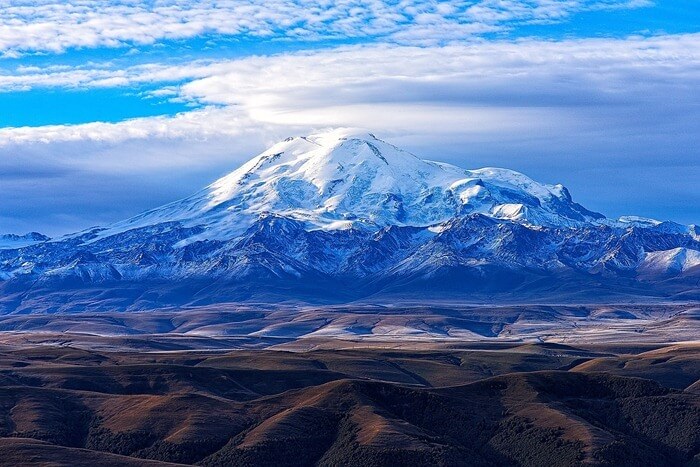
On the border between the republics of Kabardino-Balkaria and Karachay-Cherkessia is the Side Range of the Caucasus Mountains, where Elbrus, the highest mountain in Russia, is located. Elbrus has two peaks - western and eastern; the difference between them is 21 m.

This is not an easy mountain; it is a legacy of those times when the young Caucasus Mountains were still fire-breathing. Elbrus is a huge volcano, fortunately, extinct a long time ago. Over the past tens of thousands of years, Elbrus has been covered with a shell of ice of enormous thickness - in some places it reaches 250 m, which is equal to the height of an eighty-story building.

Despite its terrifying height (Elbrus is considered the highest mountain not only in Russia, but also in Europe, and is also among the top ten), the mountain’s character is not evil and the path to the top has long been found. The first ascent of Elbrus took place in the first third of the 19th century. Since then, whoever has been there! People climbed not only on foot, but also on horses, motorcycles and cars. They carried ATVs and even 75-kilogram barbells. And since the early 1990s, regular competitions have been taking place in high-speed climbing of the snow giant. From the foot to the top of Elbrus the journey takes exactly 3 hours 28 minutes 41 seconds.

List of 80 highest mountain peaks in Russia
The table shows mountain peaks with a height of at least 4000 meters and located on the territory of the Russian Federation.
| Place | Vertex | Height, m | Subject of the Russian Federation | Mountain system |
|---|---|---|---|---|
| 1 | 5642 | Kabardino-Balkaria and Karachay-Cherkessia | Greater Caucasus | |
| 2 | 5204 | Kabardino-Balkaria | Greater Caucasus | |
| 3 | 5152 | Kabardino-Balkaria | Greater Caucasus | |
| 4 | 5100 | Kabardino-Balkaria | Greater Caucasus | |
| 5 | 5085 | Kabardino-Balkaria | Greater Caucasus | |
| 6 | 5068 | Kabardino-Balkaria (Russia), Svaneti (Georgia) | Greater Caucasus | |
| 7 | 5034 | North Ossetia, Georgia | Greater Caucasus | |
| 8 | 5025 | Kabardino-Balkaria | Greater Caucasus | |
| 9 | 4970 | Kabardino-Balkaria | Greater Caucasus | |
| 10 | 4860 | Kabardino-Balkaria, Georgia | Greater Caucasus | |
| 11 | Gestola | 4860 | Kabardino-Balkaria | Greater Caucasus |
| 12 | Jimara | 4780 | North Ossetia | Greater Caucasus |
| 13 | Klyuchevskaya Sopka | 4750 | Kamchatka region | East Ridge |
| 14 | Wilpata | 4646 | North Ossetia | Greater Caucasus |
| 15 | Sauhokh | 4636 | North Ossetia | Greater Caucasus |
| 16 | Kukurtli-Kolbashi | 4624 | Karachay-Cherkessia | Greater Caucasus |
| 17 | Maylihoh | 4598 | North Ossetia | Greater Caucasus |
| 18 | Stone | 4575 | Kamchatka region | East Ridge |
| 19 | Belukha | 4509 | Altai | Altai Mountains |
| 20 | Sallynngantau | 4507 | Kabardino-Balkaria | Greater Caucasus |
| 21 | Tebulosmta | 4492 | Chechnya, Georgia | Greater Caucasus |
| 22 | Sugan | 4489 | North Ossetia, Kabardino-Balkaria | Greater Caucasus |
| 23 | Bazarduzu | 4466 | Dagestan | Greater Caucasus |
| 24 | Chanchakhi | 4461 | North Ossetia | Greater Caucasus |
| 25 | Donguzorun-Cheget-Karabashi | 4454 | Kabardino-Balkaria | Greater Caucasus |
| 26 | Shan | 4452 | Ingushetia, Georgia | Greater Caucasus |
| 27 | Warmth | 4431 | North Ossetia | Greater Caucasus |
| 28 | Chatyntau | 4411 | Karachay-Cherkessia, Georgia | Greater Caucasus |
| 29 | Adai-Khokh | 4408 | North Ossetia | Greater Caucasus |
| 30 | Songuti | 4405 | North Ossetia | Greater Caucasus |
| 31 | Tyutyubashi | 4404 | Kabardino-Balkaria | Greater Caucasus |
| 32 | Vologata | 4396 | North Ossetia | Greater Caucasus |
| 33 | Karaug | 4364 | North Ossetia, Georgia | Greater Caucasus |
| 34 | Adyrsubashi | 4349 | ||
| 35 | Laboda | 4313 | North Ossetia, Georgia | Greater Caucasus |
| 36 | Bachakhi | 4291 | ||
| 37 | Diklosmta | 4285 | Greater Caucasus | |
| 38 | Caucasus Peak | 4280 | Greater Caucasus | |
| 39 | Jorashti | 4278 | ||
| 40 | Bzhedukh | 4271 | ||
| 41 | Comito | 4261 | Chechnya | Greater Caucasus |
| 42 | Sullukolbashi | 4251 | ||
| 43 | Kayaartybashi | 4250 | ||
| 44 | Bashiltau | 4248 | ||
| 45 | Zeygalankhoh | 4244 | North Ossetia | Greater Caucasus |
| 46 | Zaromag | 4203 | North Ossetia | Greater Caucasus |
| 47 | Donchentykhoh | 4192 | North Ossetia | Greater Caucasus |
| 48 | Kalota | 4182 | North Ossetia | Greater Caucasus |
| 49 | Denunciation | 4179 | Chechnya, Georgia | Greater Caucasus |
| 50 | Addala-Schuchgelmeer | 4151 | Dagestan | Greater Caucasus |
| 51 | Chkalov Peak (Anchobala-anda) | 4150 | Dagestan | Greater Caucasus |
| 52 | Pukhgarty-Kom | 4149 | ||
| 53 | Syrkhibarzond | 4148 | North Ossetia | Greater Caucasus |
| 54 | Shalbuzdag | 4142 | Dagestan | Greater Caucasus |
| 55 | Tseyakhoh | 4140 | North Ossetia | Greater Caucasus |
| 56 | Fitnargin | 4134 | Kabardino-Balkaria | Greater Caucasus |
| 57 | Dyultydag | 4127 | Dagestan | Greater Caucasus |
| 58 | Tsmiakomhokh | 4117 | North Ossetia | Greater Caucasus |
| 59 | Barrels | 4116 | Dagestan | Greater Caucasus |
| 60 | Musostau | 4110 | Kabardino-Balkaria | Greater Caucasus |
| 61 | Baidukov Peak (Kasaraku-meer) | 4104 | Dagestan | Greater Caucasus |
| 62 | Bishnei Jenolshob | 4104 | Dagestan | Greater Caucasus |
| 63 | Belyakov Peak (Belengi) | 4100 | Dagestan | Greater Caucasus |
| 64 | Chimismeer | 4099 | Dagestan | Greater Caucasus |
| 65 | Chachkhokh | 4098 | North Ossetia, Georgia | Greater Caucasus |
| 66 | Tsunklyata | 4084 | Dagestan | Greater Caucasus |
| 67 | Tavan-Bogdo-Ula | 4082 | Altai | Altai Mountains |
| 68 | Maistismta | 4081 | Chechnya, Georgia | Greater Caucasus |
| 69 | Charundag | 4080 | Dagestan, Azerbaijan | Greater Caucasus |
| 70 | Flat Middle | 4057 | Kamchatka region | East Ridge |
| 71 | Taklik | 4049 | Dagestan | Greater Caucasus |
| 72 | Dombay-Ulgen | 4046 | Karachay-Cherkessia, Republic of Abkhazia | Greater Caucasus |
| 73 | Gockley | 4046 | Dagestan | Greater Caucasus |
| 74 | Kurmutau | 4045 | Kabardino-Balkaria | Greater Caucasus |
| 75 | Archon | 4040 | North Ossetia | Greater Caucasus |
| 76 | Izhenameer | 4025 | Dagestan | Greater Caucasus |
| 77 | Dougie | 4020 | Dagestan, Azerbaijan | Greater Caucasus |
| 78 | Deavgay | 4016 | Dagestan | Greater Caucasus |
| 79 | Kezgenbashi | 4013 | Kabardino-Balkaria | Greater Caucasus |
| 80 | Balial | 4007 | Dagestan | Greater Caucasus |
Candidate of Geological and Mineralogical Sciences I. SHCHERBA
Following in the footsteps of the past
Geochronology of the Earth over the last 200 million years.
The cliffs of the Pre-Elbrus plateau are saturated with shells of marine mollusks.
In the first half of the Jurassic period (about 100 million years ago), the Greater Caucasus Marginal Sea was part of the Tethys Ocean.
Caspian-Black Sea region during the Paleogene (about 70 million years ago).
12 million years ago, on the North Caucasian shelf there was a transverse bridge from the islands of the Sub-Caucasian archipelago.
Ancient landslides near the Zhinvali reservoir.
It was in such sandy slopes in the North Caucasus that oil was collected for centuries, gradually forming deposits like Grozny.
The phrase “Greater Caucasus” is usually associated with the idea of sparkling snowy peaks and alpine meadows. And it seems that it has always been this way, but this is not true.
Walking through the upper Kislovodsk park and admiring the view of the vast pre-Elbrus plateau, an attentive person cannot help but notice the cliffs along the paths. The rocks that make up these cliffs are abundantly saturated with shells of marine mollusks, and therefore, the sea once splashed on the site of the Caucasus Mountains. But this was more than 10 million years ago.
It is not even archaeologists, but paleontologists who operate with such time categories: they determine the age of a rock depending on whose fossilized remains (dinosaurs, mammoths or, for example, trilobites) are found in it. Time is divided into geological eras - Paleozoic, Mesozoic, Cenozoic, as well as periods - Jurassic, Cretaceous, Tertiary, Quaternary, each of which has its own epochs and centuries. It is this relative chronology that geologists use, although the absolute age of the rock is also known - it is determined by the decay of the radioactive elements it contains.
By analyzing the distribution of rocks that make up the mountains, foothills and intermountain valleys, it is possible to reconstruct the entire paleography of this area over millions of years. Such an excursion into the depths of centuries allows us to trace both temporal and territorial changes in both sedimentary rocks and tectonic structures, and fauna, different groups of which are characterized by different ecological niches.
It turns out that only 12 million years ago (Chokrak time, the middle of the second from bottom Cenozoic era), on the site of the present southern slope of the Greater Caucasus, there was a deep-sea trough, left over from an even more ancient marginal sea. The Greater Caucasus Sea was part of the Tethys paleoocean - this name was given to it by geologists after the ancient Greek goddess of the water elements. This ocean once stretched from the modern shores of the Atlantic Ocean to Indochina - through the Mediterranean, Asia Minor and Central Asia and the Himalayas - and separated two large continents - Eurasia in the north and Gondwana in the south.
Over the past 250 million years, the continents have gradually moved closer to each other, thereby reducing the water space between them. And as a result, by the middle of the Jurassic period (about 165 million years ago), the marginal sea of the Greater Caucasus was cut off from the Tethys Ocean with the help of one of these fragments - the Transcaucasian. It was an island arc consisting of fragments of pre-existing mountains (partially with volcanoes) and located within the current Transcaucasus and the eastern part of the Black Sea. The sea itself, paradoxically, was absent there, but, on the contrary, there was a certain rise of land, periodically washed away by water. And this was just then (Paleozoic and the beginning of the Mesozoic), when in place of the Greater Caucasus there was a deep sea.
The axial deep-sea trough of this sea stretched along the southern slope of the modern mountains and went in the east through the Caspian Sea to the western Kopetdag, and in the west to the southern coast of Crimea. The northern shore of the Tethys Ocean was located somewhere near Ankara and Lake Sevan. But at the end of the Cretaceous period (65-70 million years ago), the island arc that separated them split and moved to the Lesser Caucasus region. A deep-sea East Black Sea depression emerged, stretching east into Adjara and southern Georgia - all the way to Tbilisi.
The axial and highest zone of the modern Greater Caucasus belonged to the steep continental (Eurasian) slope of the marginal sea. Its slope was apparently approximately the same as that of modern continental slopes (3-6 o), which is why sediments brought from the continent in the form of sand and clay did not linger on it and were carried away to the foot. However, they occasionally survived in narrow underwater canyons, and in the southeastern Caucasus - abeam the Absheron Peninsula - they can still be observed here and there.
In flatter areas, on the contrary: along with calmly settling silts (so-called “banal” sediments), other rocks brought by turbidity and mud-stone flows were periodically deposited. The results of the rhythmic alternation of both can be seen, for example, over the beach at the southern end of Anapa Bay. Located above a narrow strip of this beach, the cliff consists of thin (less than half a meter) layers of dark clays, interspersed with thicker (up to two meters) layers of sandstones with irregular - tangled and twisted, sometimes torn - bedding, caused by their deposition from a moving mud mass.
In the era of active tectonic movements, accompanied by earthquakes, ancient landslides were also frequent, the consequences of which - in their most beautiful view- can still be observed when descending from the Cross Pass along the Zhinvali Reservoir.
At the beginning of the Paleogene (about 60 million years ago), single-celled animal foraminifera with a sandy shell settled at the foot of the continental slope of the marginal sea of the Greater Caucasus. It is precisely these representatives of a large group of foraminifera that usually inhabit areas of hydrogen sulfide contamination - mainly at a depth of at least two kilometers. The discovery of their remains in the corresponding layers allows, firstly, to determine the depth of this part of the basin, and secondly, to assert that at the beginning of the Paleogene the basin was contaminated with hydrogen sulfide (similar to the modern Black Sea). However, episodes of hydrogen sulfide contamination were repeated in the Greater Caucasus basin more than once; it reached its greatest extent 20-30 million years ago, when it captured not only the basin, but also the shelves.
During the Paleogene, the intensive rapprochement of Eurasia and Afro-Arabia continued, the entire space between them was subject to gradual compression, and the sediments of the former seas were crushed into folds.
Land barriers were formed along the borders of the continents, and the outlines of the ocean became very close to the modern contours of the Mediterranean Sea and the Indian Ocean. And yet, small shelf seas (including former marginal ones) remained covering significant areas of the present land. Even 12 million years ago, the Greater Caucasus Marginal Sea was partially preserved, and its width was four times greater than the modern width of the southern slope of the mountains. The depth of this sea in the axial part reached 500 m, and its shallowest part (a shelf with a depth not exceeding 200 m) was located in the area of the northern slope of the Greater Caucasus. The northern border of the sea extended almost to the strip of lakes that now stretches between the Azov and Caspian seas, forming the so-called Kuma-Manych depression.
From the Russian Plain, the Don and the Paleo-Northern Donets flowed into the sea, bringing huge amounts of sand and clay into it. Carried by underwater currents along the bottom, they settled along its steep ledges in the form of cones, and it was these cones that eventually became oil reservoirs in the North Caucasus. And, in particular, the huge Grozny field.
In the south, the Greater Caucasus basin was limited at that time by the Lesser Caucasus and Talysh mountains, which gave it the appearance of being inside a continental sea. Between these mountains, which began to grow 30 million years ago, there was a narrow strait, and through it the basin was connected to the shelf seas of the Mediterranean and the Indian Ocean.
The most significant uplift, and even with a dissected relief, was located at that time on the North Caucasus shelf - south of modern Stavropol. Merging with the small islands of the Sub-Caucasian archipelago, this uplift formed something like a transverse bridge inside the basin. Apparently, the aardvark pigs that came from Africa then took advantage of it: their remains were recently discovered south of Stavropol.
And about 5 million years ago, mountain growth began in the Greater Caucasus, and it was initially most intense within the former shelf. It was the central part of the Greater Caucasus (the region of Elbrus, Kazbek), which was included in mountain formation earlier than others, and became the highest in this region. But even then, the Greater Caucasus rose like an island among the seas and lakes that washed it - some of them were still discovered by primitive man.
It is divided into two mountain systems: the Greater Caucasus and the Lesser Caucasus. The Caucasus is often divided into the North Caucasus and Transcaucasia, the border between which is drawn along the Main, or Watershed, ridge of the Greater Caucasus, which occupies central position in the mountain system. The Greater Caucasus extends more than 1,100 km from northwest to southeast, from the Anapa region and the Taman Peninsula to the Absheron Peninsula on the Caspian coast, near Baku. The Greater Caucasus reaches its maximum width in the area of the Elbrus meridian (up to 180 km). In the axial part there is the Main Caucasian (or Watershed) ridge, to the north of which a number of parallel ridges (mountain ranges), including a monoclinal (cuesta) character, extend (see Greater Caucasus). The southern slope of the Greater Caucasus mostly consists of en echelon ridges adjacent to the Main Caucasus Range. Traditionally, the Greater Caucasus is divided into 3 parts: the Western Caucasus (from the Black Sea to Elbrus), the Central Caucasus (from Elbrus to Kazbek) and the Eastern Caucasus (from Kazbek to the Caspian Sea).
The most famous peaks - Mount Elbrus (5642 m) and Mount Kazbek (5033 m) are covered with eternal snow and glaciers. The Greater Caucasus is a region with extensive modern glaciation. The total number of glaciers is about 2,050, and their area is approximately 1,400 km2. More than half of the glaciation in the Greater Caucasus is concentrated in the Central Caucasus (50% of the number and 70% of the area of glaciation). Large centers of glaciation are Mount Elbrus and the Bezengi Wall (with the Bezengi glacier, 17 km). From the northern foot of the Greater Caucasus to the Kuma-Manych depression, the Ciscaucasia stretches with vast plains and hills. To the south of the Greater Caucasus are the Colchis and Kura-Araks lowlands, the Inner Kartli Plain and the Alazan-Avtoran Valley [Kura Depression, within which the Alazan-Avtoran Valley and the Kura-Araks Lowland are located]. In the southeastern part of the Caucasus are the Talysh Mountains (up to 2477 m high) with the adjacent Lenkoran Lowland. In the middle and west of the southern part of the Caucasus is the Transcaucasian Highlands, consisting of the ridges of the Lesser Caucasus and the Armenian Highlands (Aragats, 4090 m). The Lesser Caucasus is connected to the Greater Caucasus by the Likhsky ridge, in the west it is separated from it by the Colchis Lowland, in the east by the Kura Depression. Length - about 600 km, height - up to 3724 m. Mountains near Sochi - Achishkho, Aibga, Chigush (Chugush, 3238 m), Pseashkho and others (Krasnaya Polyana resort area) - will host participants in the 2014 Winter Olympic Games.


1. What is the Caucasus. Geography, structure, structure.
Many people are familiar with the Caucasus.
Gigantic mountain ranges crowned with snowy peaks raised above the clouds. Deep gorges and abysses. Endless steppe expanses. Subtropical vegetation of the warm shores of the Black Sea, dry semi-deserts of the Caspian region, flowering alpine meadows of mountain slopes. Stormy mountain streams with waterfalls, the serene surface of mountain lakes, and drying up steppe rivers of the foothills. Failed volcanoes of Pyatigorye and volcanic lava highlands of Armenia. These are just some of the contrasts of this huge region.
What is the Caucasus geographically?
In a direction roughly from north to south, the Caucasus consists of the following parts.
The Cis-Caucasian Plain, which is a natural continuation of the Russian or East European Plain, begins south of the Kuma-Manych depression. The western part of the Ciscaucasia is crossed by the flat part of the Kuban River, which flows into the Sea of Azov. The eastern part of the Ciscaucasia is irrigated by the flat section of the Terek River, which flows into the Caspian Sea. In the central part of the Ciscaucasia lies the Stavropol Upland with average heights from 340 to 600 meters and individual elevations up to 832 m (Mount Strizhament).
The next part is the Greater Caucasus. It extends over a distance of about 1,500 kilometers, from the Taman to the Absheron peninsulas.
The Greater Caucasus is formed by four mostly parallel ridges, rising step by step from north to south. The smallest Pasture Range, it is also called the Black Mountains. Behind it rises the Rocky Ridge. These two ridges are cuesta ridges, with a gentle northern slope and a steep southern slope. After Skalisty rises the Side, or Front Range, where Elbrus, Dykh-Tau, Koshtan-Tau, Kazbek and others are located.
The narrow Arkhyz-Zagedan, Bezhetinskaya and other depressions separate the Side Range from the Main, or Watershed Range.
The narrow southern slope of the Greater Caucasus gives way to the Transcaucasian depression, which consists of the Rioni or Colchis depression and the Kura depression. Between the depressions there is a narrow Suramsky or Likhsky ridge.
Even further south lies the Transcaucasian Highlands, which is part of the vast Western Asian Highlands. In the north and northeast of the highlands are the Lesser Caucasus ranges. And to the southwest of the Lesser Caucasus stretch the lava massifs of the Armenian-Javakheti Highlands.
But the Caucasus has not always been like this, and will not always be like this. This, in general, quite obvious consideration serves as a convenient transition to the question of how exactly the Caucasus was formed. Behind the rather dry phrase “geological history of the Caucasus” there are stages in the life of the living planet, the Earth, full of drama and impressive disasters. Millions of years of consistent and sometimes leisurely changes end in impulses of huge volcanic eruptions and, conversely, outbreaks of catastrophic events respond over a subsequent time interval of millions of years. And the calm muddy bottom of the warm sea becomes an icy mountain peak, from the edge of which rock falls collapse with a roar.
It is very difficult to identify a point in time from which to begin describing the history of the Caucasus. Simply because to fully understand the processes at a certain point in time, one must also know the previous episodes. When you talk about the collapse of strata, the formation of mountains at a certain point in time, the question always arises of how and when these strata themselves were formed. And those may be the products of the destruction of some more ancient mountains or structures. And so behind each ancient geological episode one can see a clear or not so clear picture of previous events...
2. Evolution of the Caucasus. From seas to mountains.
The starting, albeit very conditional, period in time, from which we can say that events are already related to the processes that led to the formation of the modern Caucasus, is the second half and end of the Paleozoic era (that is, the period of time from 400 to 250 million years ago). l.n.). At that time there were not only people on Earth, but also dinosaurs. Let's take a mental look at the entire region at that time.
There has been a strong and relatively calm Russian platform for a long time. It came together about 2 billion years ago from three blocks of crystalline foundation. These blocks were formed even earlier - from the merger of basalt plates and the further melting of their heap into granites of the continental crust.
In the second half of the Paleozoic, the Russian Platform became part of the Laurasia continent. It is gradually moving closer to another continent, Gondwana.
Let us recall the main provisions of the concept of moving lithospheric plates. Blocks of relatively hard rocks - lithospheric plates - move along the surface of the mantle under the influence of mantle convective flows - very slow on the time scale familiar to us, but quite noticeable on the geological time scale. Plates are either oceanic or continental. The continental plate along its periphery includes areas with oceanic crust. Lithospheric plates float on the surface of the asthenosphere (the asthenosphere is the upper weakened layer of the mantle with reduced viscosity) and move along it. This movement is caused by the convective movement of the mantle as a whole. The earth's crust is of two types - continental (granite) and oceanic (basalt).
New oceanic crust is formed in spreading zones - mid-ocean ridges, where the asthenosphere material builds up the plate, and is absorbed in subduction zones, where the plate material returns to the asthenosphere.
So, in the second half of the Paleozoic there is a convergence of Laurasia ( North America plus Europe) and Gondwana (Africa plus South America).
In the process of convergence in the south of the Russian Platform, where the Ciscaucasia lies today, an area of folding is formed, a mobile belt associated with the existence of a subduction zone, when the oceanic crust is absorbed under the continent, weakening its edge and providing volcanic activity and mobility of the crust of the entire region.
The global convergence at that time, at the end of the Paleozoic, ended with the collision of Laurasia and Gondwana and the formation of the supercontinent or supercontinent Pangea. Between the continents connected in the area of the modern Mediterranean Sea and diverging to the east, a wedge-shaped space was formed - the Tethys Ocean.
Locally, in the process of convergence, the mentioned moving belt experienced its evolution and lived its history. Its history is a local episode of the global picture of the convergence of lithospheric plates.
Compressional deformations in the mobile belt, which created the folded structure, began in the middle of the Visean century of the early Carboniferous period, the Carboniferous (about 335 million years ago). The cause of the deformations was the pressure of the oceanic crust on the belt in the process of convergence of continental blocks. They turned the mobile belt, the future Scythian platform, into an orogen, a mountain structure.
In the Permian period (its time interval from 299 to 250 million years ago), the orogen began to experience collapse, the rapid disappearance of mountains. The reasons for the collapse are the following. Since this orogen was not sandwiched between continental masses, but arose as a result of the withdrawal of the oceanic plate under the continent, then with the weakening of the pressure and subsidence of the oceanic plate, the forces that uplifted the mountains weakened. The blocks that made up the mountains began to slide down. Then the crumpled, compressed, crushed folds were penetrated by granite intrusions (intrusions). These intrusions seemed to reinforce and fix the folds. Pressure and temperature turned sedimentary and volcanic rocks into chlorite and sericite schists, which mainly comprise the Scythian plate.
Thus, along the northern edge of the Tethys Ocean, on the site of today’s plains of Ciscaucasia, a young (compared to the ancient East European or Russian platform) Scythian platform was formed from a mobile belt. Its latitudinal folds and slightly still moving heterogeneous blocks preserve memories of compression processes and the life of a mountain structure. Despite the fact that we practically cannot see them.
So, the main result of the events of that time, the end of the Paleozoic, was the formation of the Scythian platform, attached to the Russian platform along its current southern edge.
As geologists know, supercontinents are unstable formations. Immediately after formation, the supercontinent tends to break up. The reason for this is the same mantle flows that clustered the continents and pushed them together. Following the formation of a supercontinent, the lithosphere, which goes under it from all sides in subduction zones, accumulates under it and then floats up, splitting the supercontinent.
The Triassic period (250 - 200 million years ago, this is the first period of the Mesozoic era) was precisely the time when the split of Pangea began. The blocks of lithospheric plates that made up Pangea began to move away from each other. Africa and Eurasia began to move away from each other. The fragmentation of the continental bridge between Europe, Africa and America began.
When continental blocks move apart from each other, the oceanic crust located between these blocks grows (in fact, this is what spreading consists of). Augmentation occurs when new crust forms at mid-ocean ridges.
In our case, the axis of expansion of the Tethys Ocean fell on the northern edge of Gondwana. It was due to this, due to the formation of rifts, that continental blocks broke away from Gondwana, beginning their journey towards Eurasia. Let us recall that a rift is the initial stage of the development of the ocean as a structure; a rift may later become (but will not necessarily become!) a mid-ocean ridge. A rift is a gap that forms when the crust is pushed sideways by rising magma. Thus, in the Late Triassic, Iran and, apparently, central Türkiye broke away from Arabia. At the end of the Triassic - the beginning of the Jurassic (the Jurassic period lasts from 199 to 145 million years ago), heterogeneous blocks broke away from Gondwana, which subsequently formed into the Transcaucasian massif (in our time it separates the Greater and Lesser Caucasus).
On the opposite side of the Tethys Ocean, on the southern edge of Eurasia, oceanic crust was absorbed in subduction zones along the edge of the plate. Apparently, the formation of the crust exceeded the rate of movement of the lithospheric plates of Eurasia and Africa.
Subduction of the oceanic crust caused the emergence of a volcanic belt along the northern coast of the Tethys Ocean. Apparently, in the Triassic it was an Andean-type belt, like the modern western coast of South America.
During the Jurassic period, the second period of the Mesozoic era, the collapse of the supercontinent Pangea and its parts continued. And at the time described, the turn of the collapse of Gondwana came. In the Early Middle Jurassic, Gondwana began to split into South America, Africa with Arabia, Antarctica and India. The split of South America and Africa (with Arabia) naturally led to the growth of oceanic lithosphere between them and, which is very important for the region we are describing, to a reduction in the distance between Africa and Eurasia. The Tethys Ocean began to shrink in size.
Where the oceanic crust of the Tethys Ocean was intensely moving under the edge of the Scythian plate, a weakening of this edge occurred. This is a consequence of the fact that the oceanic plate, going down, melts, and the excess of the molten substance tries to break through upward.
Rifting began to occur on the weakened edge of the plate - the formation of rifts with the moving apart of the broken fragments of the previous foundation. The new crust expanded towards the ocean. The crust was generally continental, granitic, but intruded by basaltic outpourings. Thus (at the end of the Lower and beginning of the Middle Jurassic, about 175 million years ago) the so-called Greater Caucasus basin was formed. It was a regional sea. It was separated from the main Tethys ocean by an island volcanic arc, the existence of which is also explained by the weakening of the lithosphere in the subduction zone, underthrust, and the breakthrough of magma to the surface with the formation of volcanoes. The Greater Caucasus basin was 1700-1800 km long and 300 km wide.
Late Jurassic, 145 million years ago. The Greater Caucasus basin and island arc already exist. Note that the pictures depict structures, not seas and land. Although often the structures and pools coincide.
Almost immediately after its formation, the crust of the Greater Caucasus Basin began to sink under the continent, under the margin of Eurasia. The movement of the crust of the Tethys Ocean being absorbed to the south, causing weakening and stretching of the margin, simultaneously tries to close the newly formed basins.
And the system of volcanic arcs was awaiting a new transformation. This time at the beginning of the next, Cretaceous, period (it occupies the range of 145-65 million years ago). Stretching of the cortex in the rear of the arcs occurred again, for the same reasons as before. And already the stretching and spreading was so significant that as a result, a deep-sea depression of the Southern Caspian with oceanic crust was formed. To the west, the crust simply thinned, forming the base of the vast Proto-Black Sea basin.

At the beginning of the Late Cretaceous, about 90 million years ago, the first collision of Gondwanan continental blocks with the Lesser Caucasus island arc occurred. These blocks are central Turkey, or Kirsehir (split off from Gondwana, as mentioned earlier, in the Triassic) and the Daralagez, or South Armenian block (split off from Afro-Arabia at the end of the Early Cretaceous, 110 million years ago). The northern branch of the Tethys Ocean closed and disappeared. The remains of the bottom of this ocean, rocks called ophiolites, now lie in a strip along Lake Sevan and in a number of other places. Immediately after the collision, the subduction zone jumped further south, to the edge of the newly pushed continental blocks. This clicking relieved the compressive stress in the zone of volcanic arcs and tension again occurred in the rear of the arc. At the end of the Late Cretaceous, approximately 80 million years ago, as a result of this back-arc spreading, the Western Black Sea and Eastern Black Sea deep-sea ocean basins were formed. They are the basis of the structure of the modern Black Sea, and it can be considered that the Black Sea was created precisely then. By now, these depressions are completely filled with sediments.


Sometimes, when talking about the origin of the Black and Caspian Seas, they are called the remnants of the Tethys Ocean. This is not entirely true; these seas, as we see, are the remains of back-arc basins that were separated from the ocean by island arcs.
By the way, in the same Late Cretaceous, on the other coast of the Tethys Ocean, the southern one, an interesting phenomenon occurred. Due to the compression of the oceanic crust (as we remember, the lithospheric plates of Africa and Eurasia continued to move closer together) and the reduction of the space between the blocks of plates, this oceanic crust literally crawled onto the edge of the Arabian coast from above, and did not sink under the continent, as happens in most cases. This phenomenon is called obduction. The oceanic crust continues to lie there, occupying large areas. These are the ophiolites of Oman and others known to scientists.
Thus, the main trend in the Mesozoic period of time, in relation to the region under consideration, was the formation and evolution of island volcanic arcs and back-arc basins. This evolution is associated with the subduction zone.
Time continued to flow. The Mesozoic era gave way to the Cenozoic.
The region, like the entire planet, has entered a new period of development. Both the planet and individual places were characterized by new specific events. For the planet as a whole, the boundary of the Cretaceous (this is still the Mesozoic) and the Paleogene (this is the Cenozoic) is marked by the gradual extinction of dinosaurs and the emergence of mammals to replace them. IN flora Flowering plants enter the scene with full power, crowding out gymnosperms.
At the beginning of the Paleogene period (the Paleogene occupies the range 65 - 23 million years ago and is divided into the Paleocene, Eocene and Oligocene), the situation in the region we are talking about continued to be, in principle, similar to the Mesozoic. The Tethys Ocean gradually shrank, Africa moved closer to Eurasia. The oceanic crust subducted under the margin of Eurasia framed by island arcs.
Scientists managed to reconstruct the appearance of the region of the future Caucasus at that time. Of course, it was different from today. But its modern elements and parts became more and more clearly visible in the structures, and sometimes they looked completely different from what we see today.
Above modern Ciscaucasia, above the Scythian plate (and extending much further north) lay a vast sea basin. It was the shelf of the Eurasian continent with not too great depths. Carbonate (limestones and marls) and clay sediments accumulated at its bottom, covering the structures of the Scythian plate.
In the future, this part will become the lowland Ciscaucasia and the northern slope of the Greater Caucasus.
To the south lay a volcanic arc that separated the Greater Caucasus Basin from the rest of the Tethys Ocean. Its northern strip will in the future be the underwater rises of the Shatsky shaft and the Kurdamir shaft, as well as the Dzirul ledge. The basis of this strip is the Transcaucasian massif. The southern part of the arc will in the future become the Lesser Caucasus.
Even further south lay the vast but shrinking Tethys Ocean, and beyond it jutted out the Arabian Plate, still integral with Africa. This entire mass of blocks gradually approached the island arc.
35 million years ago, towards the end of the Eocene epoch (the second Paleogene epoch after the Paleocene), the Arabian salient almost came close and came into contact with the island arc. The bed of the Tethys Ocean, its bottom, was swallowed up under the arc.

Starting from the Oligocene (occupies the interval 34-23 million years ago), the collision of the Arabian protrusion with the island arc began. The consequence of this was the pushing of fragments of the island arc to the north and the gradual reduction of the back-arc basin. The reduction in distance was especially large directly opposite the Arabian salient, where movements reached 300-400 kilometers. The island volcanic arc curved to the north.

Oligocene, 34-23 million years ago. The beginning of block collision and crowding. The beginning of the rise of the Caucasus.
In the Oligocene, the Greater Caucasus was not yet a mountain structure. Both the Greater and Lesser Caucasus were islands and underwater hills. Their number and the area they occupied increased.
Finally, the entire space of the former Greater Caucasus basin, capable of shrinking, has ended. There was no bark left to be absorbed. Squeezed between the continental blocks between the edge of Eurasia and Afro-Arabia, the Caucasus zone has become the scene of a new stage of development (or another catastrophe, as often happens). Monstrous forces and energies again transformed the collision zone. From the late Miocene (the Miocene is a period of time from 23 to 5.4 million years ago), the uplift increased sharply. The Greater Caucasus began to rise. The sediments layered over many millions of years, lining and forming the seabed, began to turn into mountains. Apparently, at the end of the late Sarmatian century, 12 million years ago. formed in the Caucasus mountainous terrain. It is believed that the relief then was a combination of low plains in internal depressions, denudation and abrasive-erosive plains and ridges and remnant massifs up to 700 meters high above them, rising several hundred meters above them.

Fig.7 End of the Miocene, 12 million years ago. Formation of the Caucasus Mountains.
The continuing pressure of Afro-Arabia led to a weakening of the earth's crust in the area in the direction of the "edge" up to present-day Pyatigorsk, and 7-9 million years ago magmatic diapirs of the mineral water group formed there (diapiric structures are folds curved upward due to the pressure of magma from below ). Molten magma tried to make its way to the surface, swelling the sediments of the seas. But its viscosity was too high, the magma did not penetrate into the open sky, and failed volcanoes - laccoliths - now adorn the Ciscaucasia.
In the late Miocene, 7-6 million years ago. The volcanism of the Lesser Caucasus sharply increased. Extensive volcanic covers were formed from lavas and products of explosive eruptions.
In the late Pliocene, by the time of 2 million years ago. The Elbrus volcano and the Verkhnechegemskaya caldera were formed, and volcanoes arose in the Kazbek region.
Finally, in the Quaternary period (began 1.8 million years ago), the relief of the Caucasus sharply rejuvenated due to ongoing uplifts under conditions of compression between lithospheric plates. In the Greater Caucasus, the uplift of the outer elements of the mountain structure, the former shelf with a crystalline base, and the tucking of the southern slope continued. In the Lesser Caucasus, blocks simply rose along fault lines.
In the Quaternary period, volcanism in the Lesser Caucasus existed only in certain parts of it. But nearby, in the Armenian-Javakheti Plateau, the eruptions were very intense, forming the volcanoes Aragats and Ararat.
The main result of the Cenozoic events, therefore, was the collision of lithospheric plates, the closure of the Tethys Ocean and the uplift of mountain structures in place of sea basins.
3. Traces of events. What do we see today?
Now, knowing and understanding the history of the formation of the Caucasus, let us again pass from north to south over it and get acquainted with the traces of past processes. This will be a very superficial acquaintance.
The plains of Ciscaucasia are composed of Neogene and Quaternary sediments on the surface. Beneath them, and further down under the Mesozoic and Paleogene strata, lies the uneven surface of the Scythian plate.
Thanks to pressure from Arabia, the structures of the Scythian plate are partly raised, forming the Stavropol and Mineralovodsk arches.
To the right and left of this zone are the forward deflections of the plate foundation - Terek-Caspian and Western and Eastern Kuban. Thanks to their subsidence, for example, the flood plains of the Kuban and the salt lakes of the Kuma delta were formed (due to the filling of river beds with sediments).
Even further south, the Northern slope of the Greater Caucasus begins.
The rocky ridge is composed (ridge and summit plateau) of Middle Jurassic and Lower Cretaceous limestones.
In the Labino-Malkin zone, in the central part of the northern slope, the foundation of the plate simply reaches the surface in the river valleys, bent back by the monstrous pressure of the converging continents. The southern end of the Labino-Malkin zone is the Front Range, its central part.
The rising Vodorazdelny and Bokovoy ridges in the Central Caucasus are composed of hard crystalline rocks. The depression between them is composed of Early Jurassic shales.
In the Western Caucasus, the Vodorazdelny Range is composed of crystalline rocks. The lateral one is sedimentary Paleozoic.
In the Eastern Caucasus, the ridges are composed mainly of Jurassic shales
The southern slope of the Greater Caucasus is composed of Lower-Middle Jurassic shale strata. These are the same deep-sea sediments of the Greater Caucasus Basin that were mentioned earlier.
To the south is the Transcaucasian massif. In its highest place, in the center, in the Dzirula ledge, ancient pre-Paleozoic rocks are close to the surface. This is the foundation of the northern part of the former volcanic arc.
Well, then there are the Lesser Caucasus mountains, composed of volcanic-sedimentary strata of the Cretaceous and Paleogene. The thicknesses were crumpled into folds, then broken into blocks and pushed upward. This is a former volcanic arc, its southern part. The territory of the west and south of the Lesser Caucasus (Armenia, Adjara, Trialeti) is composed of Paleogene and Cretaceous marine sediments with products of underwater and above-water volcanic eruptions. The north and east of the Lesser Caucasus are composed of Jurassic marine rocks also with eruption products.
In conclusion, it is interesting to look at the region from above. You can clearly see how the Arabian Plate is being pressed into a jumble of microblocks, putting pressure on the Lesser Caucasus and further through Transcaucasia to the North Caucasus. How the chain of the Pontic Mountains (northern coast of Turkey) - Lesser Caucasus - Elburz (ridge along the southern coast of the Caspian Sea) stretches, marking the line of closure of the northern branch of the Tethys Ocean. Just to the south, the Taurus Mountains (southern Turkey) – Zagros (ridge in southwest Iran) range marks the southern branch of the Tethys Ocean. And between them, these chains, are Central Türkiye and Iran, pushed to the sides by the protrusion of the Arabian Plate.

Global view of the region.
This is what the geological history of the Caucasus looks like. As in other places on the planet, every stone means something, every slope testifies to processes millions and billions of years ago. Both small stones and structures the size of half a continent can tell their own stories, intertwining and complementing each other. So that the end result is a holistic history of the region in all its impressive dynamics. It is not easy to describe the life of the lithosphere. She doesn't know human emotions. And the witnesses to the events are not people either. And the time scales do not fit into the usual size range. Only by gathering together in the knowledge of scientists, events receive literary life. But the stones don't need us. It seems that we need them and are drawn to explore and describe them.
Steppe Ranger
Used literature:
History of the Tethys Ocean. ed. A.S. Monin, L.P. Zonenshain. 1987 156 p.
Paleogeography. A.A. Svitoch, O.G. Sorokhtin, S.A. Ushakov. 2004 448 p.
Geology of Russia and adjacent territories. N.V. Koronovsky. 2011 240 p.
Physical geography of the USSR. F.N. Milkov, N.A. Gvozdetsky. 1975 448 p.
Poetry of the Caucasus Mountains. M.G. Leonov. Nature. 2003 No. 6.


 Which letter sh is hard or soft")